Showing 31 items matching sherwood road
-
 Surrey Hills Historical Society Collection
Photograph - 15 Sherwood Road, Surrey Hills, On The Street Where You Live Project
... 15 Sherwood Road, Surrey Hills...15 Sherwood Road, Surrey Hills Photograph On The Street ...Photos documenting this address as part of a photographic series undertaken by volunteer photographers during 2013 and 2014 for The Street Where You Live Project. This was organised through the Surrey Hills Neighbourhood Centre and covered the postcode 3127 in the cities of Boroondara and Whitehorse.These photos provide a snapshot of real estate in the suburbs of Mont Albert and Surrey Hills during a period of rapid change with many properties on large blocks demolished to create higher density residential development or renewal of single dwellings. At particular risk were properties not covered by heritage overlays, especially interwar housing and post 1950's housing. -
 Surrey Hills Historical Society Collection
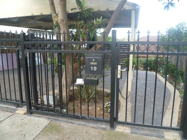
Photograph - 19 Sherwood Road, Surrey Hills, On The Street Where You Live Project
... 19 Sherwood Road, Surrey Hills...19 Sherwood Road, Surrey Hills Photograph On The Street ...Photos documenting this address as part of a photographic series undertaken by volunteer photographers during 2013 and 2014 for The Street Where You Live Project. This was organised through the Surrey Hills Neighbourhood Centre and covered the postcode 3127 in the cities of Boroondara and Whitehorse.These photos provide a snapshot of real estate in the suburbs of Mont Albert and Surrey Hills during a period of rapid change with many properties on large blocks demolished to create higher density residential development or renewal of single dwellings. At particular risk were properties not covered by heritage overlays, especially interwar housing and post 1950's housing. -
 Surrey Hills Historical Society Collection
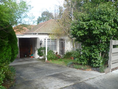
Photograph - 13 Sherwood Road, Surrey Hills, On The Street Where You Live Project
... 13 Sherwood Road, Surrey Hills...13 Sherwood Road, Surrey Hills Photograph On The Street ...Photos documenting this address as part of a photographic series undertaken by volunteer photographers during 2013 and 2014 for The Street Where You Live Project. This was organised through the Surrey Hills Neighbourhood Centre and covered the postcode 3127 in the cities of Boroondara and Whitehorse.These photos provide a snapshot of real estate in the suburbs of Mont Albert and Surrey Hills during a period of rapid change with many properties on large blocks demolished to create higher density residential development or renewal of single dwellings. At particular risk were properties not covered by heritage overlays, especially interwar housing and post 1950's housing. -
 Surrey Hills Historical Society Collection
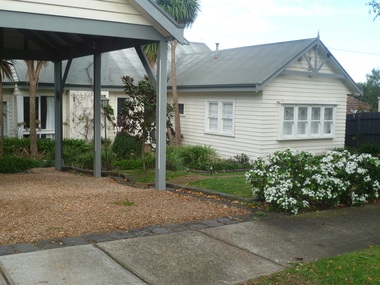
Photograph - 17 Sherwood Road, Surrey Hills, On The Street Where You Live Project
... 17 Sherwood Road, Surrey Hills...17 Sherwood Road, Surrey Hills Photograph On The Street ...Photos documenting this address as part of a photographic series undertaken by volunteer photographers during 2013 and 2014 for The Street Where You Live Project. This was organised through the Surrey Hills Neighbourhood Centre and covered the postcode 3127 in the cities of Boroondara and Whitehorse.These photos provide a snapshot of real estate in the suburbs of Mont Albert and Surrey Hills during a period of rapid change with many properties on large blocks demolished to create higher density residential development or renewal of single dwellings. At particular risk were properties not covered by heritage overlays, especially interwar housing and post 1950's housing. -
 Surrey Hills Historical Society Collection
Photograph - 11 Sherwood Road, Surrey Hills, On The Street Where You Live Project
... 11 Sherwood Road, Surrey Hills...11 Sherwood Road, Surrey Hills Photograph On The Street ...Photos documenting this address as part of a photographic series undertaken by volunteer photographers during 2013 and 2014 for The Street Where You Live Project. This was organised through the Surrey Hills Neighbourhood Centre and covered the postcode 3127 in the cities of Boroondara and Whitehorse.These photos provide a snapshot of real estate in the suburbs of Mont Albert and Surrey Hills during a period of rapid change with many properties on large blocks demolished to create higher density residential development or renewal of single dwellings. At particular risk were properties not covered by heritage overlays, especially interwar housing and post 1950's housing. -
 Surrey Hills Historical Society Collection
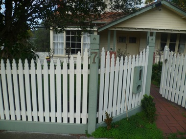
Photograph - 7 Sherwood Road, Surrey Hills, On The Street Where You Live Project
... 7 Sherwood Road, Surrey Hills...7 Sherwood Road, Surrey Hills Photograph On The Street ...Photos documenting this address as part of a photographic series undertaken by volunteer photographers during 2013 and 2014 for The Street Where You Live Project. This was organised through the Surrey Hills Neighbourhood Centre and covered the postcode 3127 in the cities of Boroondara and Whitehorse.These photos provide a snapshot of real estate in the suburbs of Mont Albert and Surrey Hills during a period of rapid change with many properties on large blocks demolished to create higher density residential development or renewal of single dwellings. At particular risk were properties not covered by heritage overlays, especially interwar housing and post 1950's housing. -
 Surrey Hills Historical Society Collection
Photograph - 3 Sherwood Road, Surrey Hills, On The Street Where You Live Project
... 3 Sherwood Road, Surrey Hills...3 Sherwood Road, Surrey Hills Photograph On The Street ...Photos documenting this address as part of a photographic series undertaken by volunteer photographers during 2013 and 2014 for The Street Where You Live Project. This was organised through the Surrey Hills Neighbourhood Centre and covered the postcode 3127 in the cities of Boroondara and Whitehorse.These photos provide a snapshot of real estate in the suburbs of Mont Albert and Surrey Hills during a period of rapid change with many properties on large blocks demolished to create higher density residential development or renewal of single dwellings. At particular risk were properties not covered by heritage overlays, especially interwar housing and post 1950's housing. -
 Surrey Hills Historical Society Collection
Photograph - 5 Sherwood Road, Surrey Hills, On The Street Where You Live Project
... 5 Sherwood Road, Surrey Hills...5 Sherwood Road, Surrey Hills Photograph On The Street ...Photos documenting this address as part of a photographic series undertaken by volunteer photographers during 2013 and 2014 for The Street Where You Live Project. This was organised through the Surrey Hills Neighbourhood Centre and covered the postcode 3127 in the cities of Boroondara and Whitehorse.These photos provide a snapshot of real estate in the suburbs of Mont Albert and Surrey Hills during a period of rapid change with many properties on large blocks demolished to create higher density residential development or renewal of single dwellings. At particular risk were properties not covered by heritage overlays, especially interwar housing and post 1950's housing. -
 Surrey Hills Historical Society Collection
Photograph - 9 Sherwood Road, Surrey Hills, On The Street Where You Live Project
... 9 Sherwood Road, Surrey Hills...9 Sherwood Road, Surrey Hills Photograph On The Street ...Photos documenting this address as part of a photographic series undertaken by volunteer photographers during 2013 and 2014 for The Street Where You Live Project. This was organised through the Surrey Hills Neighbourhood Centre and covered the postcode 3127 in the cities of Boroondara and Whitehorse.These photos provide a snapshot of real estate in the suburbs of Mont Albert and Surrey Hills during a period of rapid change with many properties on large blocks demolished to create higher density residential development or renewal of single dwellings. At particular risk were properties not covered by heritage overlays, especially interwar housing and post 1950's housing. -
 Surrey Hills Historical Society Collection
Photograph - 1 Sherwood Road, Surrey Hills, On The Street Where You Live Project
... 1 Sherwood Road, Surrey Hills...1 Sherwood Road, Surrey Hills Photograph On The Street ...Photos documenting this address as part of a photographic series undertaken by volunteer photographers during 2013 and 2014 for The Street Where You Live Project. This was organised through the Surrey Hills Neighbourhood Centre and covered the postcode 3127 in the cities of Boroondara and Whitehorse.These photos provide a snapshot of real estate in the suburbs of Mont Albert and Surrey Hills during a period of rapid change with many properties on large blocks demolished to create higher density residential development or renewal of single dwellings. At particular risk were properties not covered by heritage overlays, especially interwar housing and post 1950's housing. -
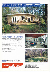 Eltham District Historical Society Inc
Folder, Sherwood, 5 Haldane Road, Eltham
... Sherwood, 5 Haldane Road, Eltham... melbourne Folder Sherwood, 5 Haldane Road, Eltham 1 document, 2 ...Morrison Kleeman Real Estate sales information material1 document, 2 pages A4 gayle blackwood collection, houses, morrison kleeman real estate, mudbrick, haldane road, eltham south, sherwood -
 Surrey Hills Historical Society Collection
Folder of real estate advertisements, Folders of real estate advertisements (Streets beginning with S), Various
... sherwood road... shepherd street shepreth street sherwood road shrimpton court sir ...A4 folders with individual pockets for each property in streets beginning with S located in Surrey Hills and Mont Albert. Folders are ordered by street name and then chronologically by property number. Each property has its own pocket. This may include multiple real estate advertisements collected from sales over time. It may also include copies of any research undertaken by Alan Holt and / or members of the SHNCHC team. These are augmented by cards in the Alan Holt index file and by his property registers of Surrey Hills and Mont Albert.st georges avenue, st james avenue, salisbury avenue, scheele street, scottsdale street, serpentine street, shepherd street, shepreth street, sherwood road, shrimpton court, sir garnet road, smythe avenue, stanhope street, streeton court, suffolk road, sunbury crescent, surrey avenue, sydenham lane, sythney court -
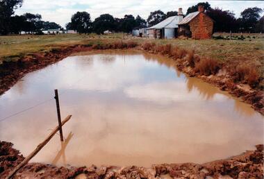 Hume City Civic Collection
Photograph, Early 1980's
... buildings waylett james farm buildings sherwood somerton road ...The mud brick cottage and outbuilding was possibly built by James Waylett in the 1850's and it is only one of three remaining mud brick buildings in the Oaklands-Greenvale which were constructed in the late 19th Century.A coloured photograph of farm scene. A dam is in the foreground and the remains of a mud brick cottage and timber and corrugated building in the middle distance. Further farm buildings can be seen in the distance.mud brick buildings, waylett, james, farm buildings, sherwood, somerton road, oaklands hunt club, george evans collection -
 Hume City Civic Collection
Photograph, c late 1990s
... proximity to a proposed housing estate at Sherwood near Racecourse... and its close proximity to a proposed housing estate at Sherwood ...The series of 9 photographs were taken to be included in a study of archaeological sites and Aboriginal rings in the Sunbury area. Five earth rings which are thought to be associated with male initiation ceremonies have been identified in Sunbury. Only 3 others have been found in the rest of Victoria. Despite rapid development in the area, those sites are protected heritage sites.A view of the Aboriginal ring and sacred site and its close proximity to a proposed housing estate at Sherwood near Racecourse Road.aboriginal culture, aboriginal rings, sacred sites, george evans collection -
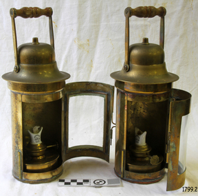
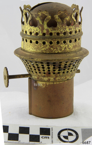 Flagstaff Hill Maritime Museum and Village
Domestic object - Lamp Burner, Isaac Sherwood & Son Ltd, 1904-1920
Sherwood Ltd. Was a manufacturer of oil lamps and burners at the Nechells Park Works Birmingham UK and regarded at the time as a renowned name in the oil lamp and burner manufacturing industries in Birmingham during the early part of the 20th century. They started selling as ‘Isaac Sherwood & Son Ltd.’ in 1904, later around 1920 they merged with Linley and Co makers of American pattern lamps and became ‘Sherwood-Linley” moving to 44-50, Granville St. Birmingham. They became one of the largest manufacturers of lighting devices and burners in England. They produced all sorts of illumination devices and became famous for their oil burners. Apart from oil burners, they produced table and floor lamps, sconces, lanterns and chandeliers that made Sherwood unique. A Significant item as part of a kerosene lamp that was commonplace in homes and other premises during the early 20th century as a means of lighting before electric lighting became the standard. These types of items give a snapshot into domestic and social life during this period.Lamp Burner housing, brass with wick-screw (no wick). Made in England Sherwoods LTD Birminghamwarrnambool, flagstaff-hill, shipwreck-coast, flagstaff hill, warrnambool, flagstaff-hill, flagstaff-hill-maritime-museum, maritime-museum, shipwreck-coast, flagstaff-hill-maritime-village, lamp burner, sconces, kerosene lamp, wick adjuster, sherwood & son ltd, sherwood-linley -
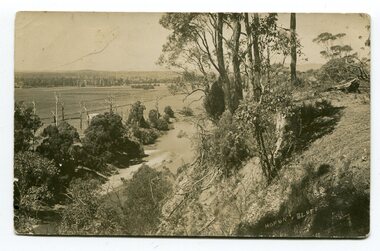 Orbost & District Historical Society
black and white postcards, Sherwood, Herbert, first half 20th century
3185.1 is a view from Hofen's Bluff at Bete Bolong. 3185.2 is a view taken from Mt Raymond looking west at swampland. 3185.3 was taken from Warrens Road, Newmerella looking over the flats towards Orbost, north-east. 3185.4 was taken at Cameron's Lagoon / Lochiel Lagoon in Orbost.These postcards are pictorial records of Orbost in the first half of the 20th century.Four black / white postcards of views around Orbost. postcards-orbost hofen's-bluff newmerella lochiel-lagoon cameron's-lagoon -
 Warrnambool and District Historical Society Inc.
Document, Angler's map Hopkins River, 1980s
This is a map of the Hopkins River Estuary prepared by Dr John Sherwood for the benefit of anglers. The information on the sheet includes the location of sand banks, the water depths, boat ramp facilities and public access facilities. Some of the information has been gathered from aerial photographs. The map has been produced by the Warrnambool Institute of Advanced Education which was developed in the late 1960s from the tertiary section of the Warrnambool Technical College and with all its departments established by 1984 at the Sherwood Campus five kilometres from Warrnambool on the Princes Highway. Today the site is occupied by Deakin University, Warrnambool campus. The Warrnambool Anglers’ Club has its headquarters on the banks of the Hopkins River near the mouth of the river and the Lyndoch Aged Care facility.This map is of interest as a specialist one, providing fishermen with detailed information on all aspects of the Hopkins river estuary. Fishing has been both a profession and a popular recreational pursuit for Warrnambool residents since the early days of the city’s settlement. The Hopkins River Estuary has been a focal point for fishermen throughout Warrnambool’s history. This is a sheet of paper folded three times to produce a folded map. The front cover has a black and white photograph of two fishermen with a large fish. The map of the Hopkins River Estuary is in yellow, blue and black and covers the side of one sheet and three quarters of the other side. There is an advertisement for the Hopkins River Boathouse with a black and white sketch of the boathouse and notes on the map written by Dr John Sherwood. There are several diagrams showing the water depths. The map has some silverfish damage and some tearing at the folds. warrnambool anglers’ club, history of warrnambool, hopkins river, hopkins river estuary, john sherwood -
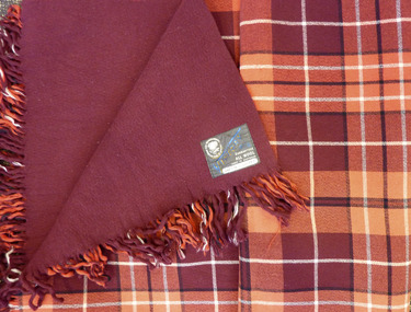 Warrnambool and District Historical Society Inc.
Textile - Woollen Blanket, Warrnambool Woollen Mill, Circa 1949
The first Warrnambool to Melbourne cycling race was held in October 1895. 24 riders started with only 7 finishing the race. W. Nicol was the winner of the inaugural race. Two months later on 14/12/1895 the race was run in reverse. For the ensuing 43 years it was mainly Melbourne to Warrnambool. Since 1939 it has been run mainly Melbourne to Warrnambool. The prize of this blanket was 2nd prize to E. Ion of Tasmania in October 1949. The prize itself, A Warrnambool Blankets Tartan rug was made at the Warrnambool Woollen Mill in Harris St Warrnambool Early efforts to establish a woollen Mill in Warrnambool commenced with an early mill on the Merri at Woodford in 1874 but the site proved unsuitable and was financially struggling. The decision was made to move plant and and machinery to the old meat preserving factory in South Warrnambool The plant and equipment was sold to Mr Robert Hood of Sherwood on the Hopkins River East Warrnambool who carried on the venture until fire destroyed the building in 1882, The site lay idle until a group of local businessmen raised 40000 pounds to establish the mill in 1910. It continued to trade well through the early and mid 20th century. Dunlop brought the mill in 1968 and there was a slow downturn with numerous owners until it closed in 2000. The site passed into private hands in 2003.Both the Warrnambool Woollen Mill and the Melbourne to Warrnambool Road Race are a significant part of local history. The Melbourne to Warrnambool Cycling road race remains one of the premier sporting events in Australia. It commenced in 1895 Maroon and red block check with black and white check lines on front with plain maroon back. Fringed on two sides. Grey cotton label with The Warrnambool Woollen Mill Co Limited in top Left hand side of label, Victory Rug diagonally in blue Guaranteed All WOOL Made in Australia in bottom RH corner of label. Owner M bottom of label. 1949 Mr. Ernie Ion” handwritten in black pen.warrnambool, warrnambool woollen mill, marcus saltau, w. nicol -
 Warrnambool and District Historical Society Inc.
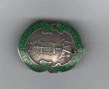
Badges, Warrnambool Technical School
This is a Warrnambool Technical School badge of the 1920s and 30s. Warrnambool Technical School was established in Timor Street in 1913. The senior section was later called Warrnambool Technical College and then Warrnambool Institute of Advanced Education. The latter institute moved to Sherwood Park, Warrnambool and became the present-day Warrnambool campus of Deakin University. Warrnambool Technical School moved to Caramut Road, Warrnambool and is today known as Brauer College. The badge was donated by Mirth Marfell, the daughter of Henry and Helena Marfell. She was born in Warrnambool in 1919. Her grandfather, John Marfell, a Warrnambool hay and corn dealer and miller connected to the Warrnambool Co-operative Milling Company, was prominent in community and civic affairs in the town. Mirth Marfell completed her nursing training at the Warrnambool Base Hospital and served in the Australian Army Nursing Service in World War Two for five years. She then became the first Australian nursing organizer for the Victorian Royal College of Nursing. This badge is of interest, firstly as a memento of Warrnambool Technical School from the 1920s and 30s and secondly because it came from Mirth Marfell, a Warrnambool person who had a distinguished nursing career..1 Shield shaped metal and enamel badge with green border including text enclosing a silver area featuring raised images of a torch, scales, compass, hammer, nails, artist's palette, brushes , a bar and the numbers 192. A pin clip is on the reverse .2 Circular metal and enamel badge with a golden edged green border surrounding a bronze coloured centre with a stylised golden edged scarlet torch and three horizontal bars of varied length. A pin clip is on the reverse..1 WARRNAMBOOL TECn SCHOOL LABOR TO EFFICIENCY .2 WARRNAMBOOL TECHNICAL SCHOOLwarrnambool institute of advanced education, warrnambool technical school, brauer college, warrnambool co-operative milling company, victorian royal college of nursing, history of warrnambool -
 Warrnambool and District Historical Society Inc.
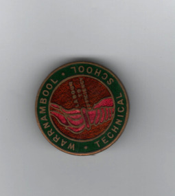
Badge, Warrnambool Technical school
This is a badge from Warrnambool Technical College in the 1930s. Warrnambool Technical School was established in Timor Street in 1913. The senior section was later called Warrnambool Technical College and then Warrnambool Institute of Advanced Education. The latter institute moved to Sherwood Park, Warrnambool and became the present-day Warrnambool campus of Deakin University. Warrnambool Technical School moved to Caramut Road, Warrnambool and is today known as Brauer College. The badge came from Mirth Marfell, the daughter of Henry and Helena Marfell. She was born in Warrnambool in 1919. Her grandfather, John Marfell, a Warrnambool hay and corn dealer and miller connected to the Warrnambool Co-operative Milling Company, was prominent in community and civic affairs in the town. Mirth Marfell completed her nursing training at the Warrnambool Base Hospital and served in the Australian Army Nursing Service in World War Two for five years. She then became the first Australian nursing organizer for the Victorian Royal College of Nursing. The badge has also belonged at one stage to W Goodall a member of a well known Warrnambool family.This badge is of interest, firstly as a memento of Warrnambool Technical School from the 1920s and 30s and secondly because it came from Mirth Marfell, a Warrnambool person who had a distinguished nursing career.A circular metal and enamelled badge featuring a crimson torch and text on a bronze background surrounded by a dark green golden edged border with text. The reverse has a pin clip and text.WARRNAMBOOL. TECHNICAL..SCHOOL STOKES W GOODALLwarrnambool technical school, history of warrnambool, warrnambool institute of advanced education, deakin university campus, brauer college, mirth marfell, victorian royal college of nursing -
 Warrnambool and District Historical Society Inc.
Pennant
This pennant was used by one of the school houses at Warrnambool Technical College. Warrnambool Technical School was established in Warrnambool in 1913. The name was changed to Warrnambool Technical College in 1958. In 1974 the junior section of the Technical College was moved to Caramut Road and is now called Brauer College. The senior section became the Institute of Adult Education and moved to Sherwood Park in 1984 , this is now Deakin University. and Timor Street is now Technical and Further Education. The name of the house " Shomberg" comes from the ship that was wrecked near Peterborough, Victoria in 1855.This pennant is retained because of its connection with Warrnambool Technical School, an important educational establishment.A triangular red felt pennant with white felt loops for attaching to a stand. It has white printing and a white image of a sea horse stencilled on.WARRNAMBOOL TECHNICAL COLLEGE " Schomberg" -
 Warrnambool and District Historical Society Inc.
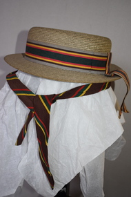
Hat & Neck Tie, Warrnambool Technical School, 1970s
These two hats and school tie were once part of the uniform for girls at Warrnambool Technical School. This school was established in 1913 in Timor Street, Warrnambool with the first Principal being John King. From this school evolved the Warrnambool Institute of Advanced Education which itself was subsumed into the present day Deakin University campus at Sherwood Park in Warrnambool. The Timor Street site is now the location of South West College of TAFE. The WarrnamboolTechnical School moved from Timor Street to its present-day site in Caramut Road Warrnambool in 1973 and was re-named Brauer College in 1990 after Alfred Brauer, a Warrnambool doctor and a prominent school patron. It is believed that the owners of the hats, Jeannie and Sandra Cole were sisters.These two hats and the tie are interesting reminders of the uniform of a local school some 40 or 50 years ago..1 This is a girl’s boater-shape straw hat. It has a ribbon band in grey, brown, yellow, red and green colours with a bow at the back with overhanging ends of the band. The hat has a cloth lining with a tag. The owner’s name is inside the hat. .2 This is a girl’s boater-shape straw hat. It has the same band as the one above but the crown on this hat is semi-detached. The owner’s name is on the inside of the hat. .3 This is a school tie. It is brown with gold, dark green and red diagonal stripes. .1 Jeannie Cole Made of straw fibre .2 Sandra Cole Made of straw fibre Created by Effie Jay showerproof with water repellent formula KO/3420 warrnambool technical school, history of warrnambool -
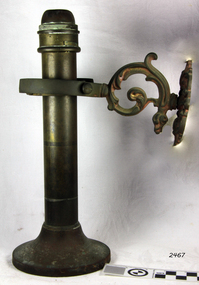
 Flagstaff Hill Maritime Museum and Village
Binnacle Lamp
Nautical Binnacle oil lanterns (2), brass with glass hinged door, ventilation holes in base. Wooden handle, removeable brass fuel tank, internal reflector, clear door has a sliding catch. Lamp has a new ceramic wick-holder inprinted with "Sherwoods Ltd" and "Sound". Used in Binnacles to light at night.flagstaff hill, warrnambool, shipwrecked-coast, flagstaff-hill, flagstaff-hill-maritime-museum, maritime-museum, shipwreck-coast, flagstaff-hill-maritime-village, nautical binnacle, nautical binnacle oil lanterns, sherwoods ltd, binnacle -
 Flagstaff Hill Maritime Museum and Village
Lamp, Late 19th Century
Isaac Sherwoods Ltd were manufacturers of oil lamps and burners in Birmingham, in 1904 they were trading as Isaac Sherwood & Son Ltd. but by 1920 they had taken over Linley & Co. of 73-75 Great Lister Street, makers of `American' pattern lamps to become Sherwood-Linley at Nechells Park Works, Eliot Street. The company were a leading manufacturer of oil and candle lamps exporting their goods all over the world. The subject lamp is operated with a candle, which is inserted on the underside, it is sprung and as the candle burns the spring keeps the candle pushed upwards keeping the flame burning until the candle is extinct. Sherwoods invented and patented this innovation for candle lamps.The subject item is incomplete however it has some significance as it was designed to be used in a sea going vessel, as a result is quite rare also the item is made by a well known manufacturer.Spring loaded candle Lamp, brass, with gimbal wall attachment for use on a ship, shade and mount missing. Candle-stop has the words "Sherwoods Limited, trademark sound".flagstaff hill, warrnambool, shipwrecked-coast, flagstaff-hill, flagstaff-hill-maritime-museum, maritime-museum, shipwreck-coast, flagstaff-hill-maritime-village, candle lamp, gimbal spring, sherwoods limited -
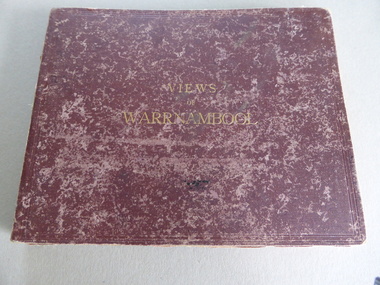 Warrnambool and District Historical Society Inc.
Album, Photographs Views of Warrnambool, c 1891
This album contains photographs of many Warrnambool buildings and scenes, including Proudfoot Boatsheds, St. John’s Church, Christ Church, Shelly Beach, Hopkins Falls, Sherwood gardens and buildings, Ozone Coffee Palace, Kepler Street, Sandstone Quarries and the Titan Crane on the Breakwater. The photographs have been taken and put in album form by the photographer Joseph Jordan. The advertisements of the hotels on the inside covers place the publication of the album to the years1891-2. We have another album similar to this but there are six photographs in this album (VC000799) that are not in the other album. These extra photographs are of the original gardens and buildings of Sherwood.This is a most important album as the photographs are clear and show a good cross-section of Warrnambool in the early 1890s. Some of the photographs are not represented in other collections (eg Sherwood gardens) and so are of vital historical significance. The advertisements are also of great use to researchers.This album has a brown hard cover and contains three pages of local advertisements and sixteen pages of photographs and 32 photographs back to back. The pages have been bound but some pages have come loose. There is a fold-out section of a 180 degree panorama of Warrnambool taken from Liebig Street hill. The edges of these pages have been taped.Front Cover- Views of Warrnamboolwarrnambool, views of warrnambool, photos of warrnambool -
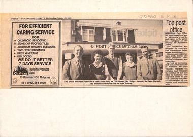 Whitehorse Historical Society Inc.
Newspaper - Article, Top Post Office, 25/10/1989
Article in Nunawading Gazette. Mitcham Post Office won an award for excellence, judged on team work, health & safety provisions, community involvement and innovation. The award was devised by Australia Post to encourage better service to customers.postal services, mitcham post office, striving for excellence award, toliday, ross, sherwood, melanie, mansell, dean, kendall, robyn, brown, cliff -
Canterbury History Group
Drawing - Illustration, Original house names on original Strathcona property, 1/12/2008 12:00:00 AM
Illustration prepared by Glen Turnbull of the original house names on the original Strathcona property. This covers the area bounded by Scott Street, Bryson Street, Claremont Crescent and Prospect Hill Road, Canterbury.canterbury, strathcona baptist girls grammar school, scott street, bryson street, claremont crescent, prospect hill road, claremont park estate, "glen allen", "shalimar", "hilary", "sherwood", "marshalton", "elston", "whitefoord", "natrie" -
Glenelg Shire Council Cultural Collection
Administrative record - Port of Portland 26th Annual Report for the year ended June 30, 1977, Osborn Mannett, 1977
Formerly Bower Bird Museum, Sherwoodport of portland -
Glen Eira Historical Society
Ephemera - Carnegie Cricket Club
This file contains nineteen Carnegie Cricket Club season match cards owned by the club’s Honorary Secretary for 1930-1931, and life member, Mr. T. E. S. Ash. The cards encompass the years from 1930-1931, 1936-1938, 1940-1941, 1943-1951 and 1952-1960. Each of the match cards list the office bearers for the year as well as the club’s fixtures. Some contain handwritten annotations by Mr. Ash as to the outcomes of the matches.ash mr., shelton j. n., reid s. h., price c., harratt f., stevenson h., donaldson t., walker a., cakebread e., gregg r., tebbs j., tempany t., quinn p., price f., lonch w., newing s., henderson e., reader a., larter f. t., harwood h., ash t. e. s., neerim road, bone j., jenner t., paul j., richards u., diamond c., mckee w., reid s. h., robertson g., sherwood j., tyers s. w., allaway j. e., clarke t. b., goldman a., jukes a., spencer w., beaumont c., carnegie, wishart g., bone r., boxshall k., cameron h., johnson a., hubbard l., larter f., price c. l., moore d., allaway e., ash t., louch w. h., goodall m., reid g., graham j., reid m., wilde w., willison p., murrumbeena, henty street, crussell j. a., williams h., allan p., pooley p. c., greig g., pierce l., caples r. w., newbury c. j., chamberlain a., cusack r., driver w. j., mau r., moore d. c., wishart m., pummeroy k., bailey f. i., brown r. w., whelan j. g., parker c., rofe r., wilkins d., dann e., tebbs j. (junior), yenden road, loush w., neville street, williams r. h., greenway a., lewis j., rolfe d., saunders r., wishart d., st. anthony, glenhuntly, stocks w., christie a., greenway a. e., caulfield south, ireland p., mcdougall c. j., burke s., pert r. g. a., mimosa road, carn. soc., carnegie socials, caulfield sth, ormond a, sweetnam r. w., price f. n., bone r. n., burke s. r., mcintosh a., ormond, caulfield east, ormond park, murrumbeena c, murrumbeena d, elsternwick, murrumbeena e, carnegie soldiers, mccarron a., newbury c. r., middleton j., o’connor j., cakebread j., morton l., lyons street, mckinnon, carnegie traders, bone r. j., north road, caul. f’balls, caulfield north, clarke t., whitelaw w., sweetman r. w., jury j., macfarlan i., daniells j. (senior), price r., bull a. j., tranmere avenue, wakeman o. w., coorigil road, bailey i., james p. c., ormond b, james p., pert r., green w., knox h., reid street, caulfield, heib j., price v. j., elliot a., phillips n., wilde w. j., cusack s., tyers n. s., hender b., george d., ford j., castles p., rolfe d. h., cusack r. s., gamble h., louch w. h., pearce e., koornang road, koornan road, harrington a., somerville h. j., grange road, sutherland m., bent street, rowland s., chestnut street, ariadne avenue, rankin ian, caulfield city, carnegie r. s. l., caulfield foot, murrumbeena foot, whitelaw m., chilvers r., kennedy d., mclatchie h., murrumbeena z, ormond c. of c., murrumbeena b, bentleigh, crussell j., mckee g., andrews e. j., andrews n., somerville h., moonya road, murrumbeena park, sweetnan r. w., hubbard l. c., harwood h. j., wilkins d. (senior), sporting clubs, cricket, clubs and associations, volunteers -
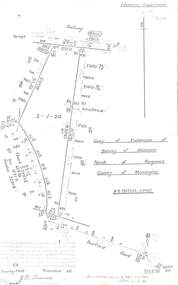 Ringwood and District Historical Society
Document - Copy of Lands Department Field Notes - Parish of Ringwood, Victoria, Field Notes 55114 Survey of Allotment by J.D. Sherwood in 1955
... Department, A-B Datum 117degrees20', Bedford Road, Certification... Department, A-B Datum 117degrees20', Bedford Road, Certification ...5618b Foolscap size photocopy of survey map with handwritten notations. References include Railway (Reserve), Education Department, A-B Datum 117degrees20', Bedford Road, Certification by J.D. Sherwood Licensed Surveyor 23/11/1955.